
I have always considered the use of mapping as an interesting way to look at ‘lived experience’ and to learn more about constructed ideas of place within a space. For my mapping project, I took a tiny step toward exploring my own experience while studying abroad in the fall of 2016.
I decided to work with ArcGIS StoryMaps because I had worked with ArcGIS Desktop in the past and was interested to see how the online/public interface worked. I also chose this tool because it allowed me to incorporate other forms of media alongside my map rather easily.
Link to map: https://storymaps.arcgis.com/stories/4269030d3a224bb58c0ef712de4ac352
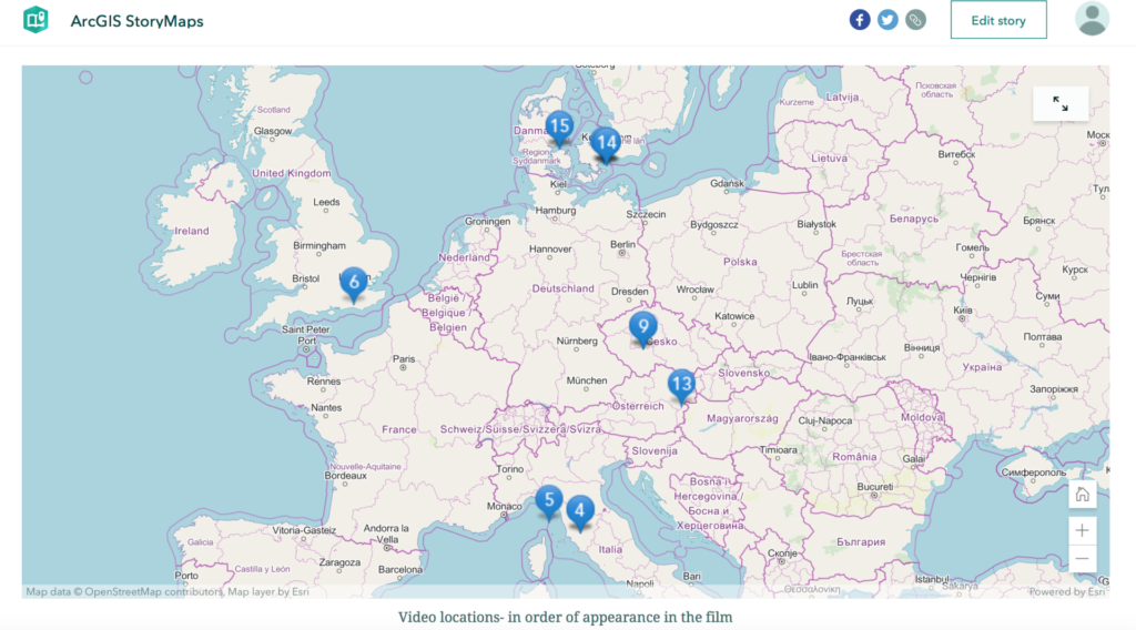
While contemplating what to map I decided to focus on a film I created for a class in my undergraduate career that combined many video clips from my time abroad. This film served as a contained example of what I could do if I wanted to explore my entire abroad experience through my entire collection of photos and videos. For my base map, I chose to use the OpenStreetMap Vector base map because it resembles Apple Maps and Google Maps, both of which I used constantly when traveling abroad. By using the OpenStreetMap, I included an element of my experience that cannot be separated from my pictures and videos.
I started by plotting the exact location of each video clip on the map. I gave each point a number that corresponded to the order the video clip appeared in the film. For example, the first clip is from the rainbow panorama art installation at the Aarhus Art Museum in Aarhus, Denmark. This location is marked with a ‘1’ since it appeared in the film first. I experimented with the labeling of my points. For some, I gave the name of the location where the clip was filmed, for others I gave a descriptive title related to the content of the clip. If I continued working on this map, I think it would be useful to have the exact location of the photo or video along with a description of the content together because it would incorporate a geographical location with my interpretation/feelings/understanding of each location. I believe this to be more compelling when examining an individual’s ‘connection’ to a point in space.
I wanted to feature additional photos I took from the locations of the video clips on the map but I could not figure out a way to upload them without first bringing them online so they could be embedded. To remedy this, I chose to include photos within the storymap using the sidecar feature. I added three photos corresponding to the first three locations presented in the film. In the description box, next to each of the photos I listed a number that corresponds to the numbered location on the map. I also gave the name of the geographical location found on Google maps, as well as the date I visited each location. If I move forward with this project, I think it would be interesting to have each marked location on the map have a sidecar with additional photos of the landscape, photos of items collected from the site like a museum ticket, diary entries, and other media to create a fuller picture of my lived experience.
While working with ArcGIS StoryMaps, I did run into a few issues. Originally, I wanted to upload my film directly to the page but was unable to because it was in .mov format instead of .mp4. I had to embed the link to the film on YouTube to have it appear within my story. Some of my points are close together, so when the map is zoomed out not all points are visible. The scale of the map does not allow all points to be seen within the same frame; I think this diminishes the ability to geographically visualize the film as a whole because not all the locations are displayed. I already mentioned above my issue with adding photos to my map and my solution by using the sidecar feature. While this feature somewhat solves the problem, I think it creates distance between the film, map, and photos, causing them to seem disjointed. Ideally, an individual would see them all together, creating a fuller multimedia experience. By looking at each element separately it is harder to recreate my lived experience and does not allow for a user to explore/view the media together.
In my field of study, I think StoryMaps could be used to explore the lives of historical figures or even specific communities in a more expansive way. This tool allows for the visual exploration of many materials that allude to an individual or community’s perceptions of a place. Additionally, by attempting to create a map that reflects my experiences abroad, I think StoryMaps could be used outside academia as a social platform for displaying a person’s journey/experience/life. I won’t say if this could be good or bad, but it is thought-provoking in terms of social media’s role in the world today.